Advances in digital aerial imagery, satellites, LIDAR and drones are providing a more detailed understanding of commercial property risks than ever before. While the insurance market is the main beneficiary, risk professionals can also benefit from these advances to help manage costs and understand property conditions.
The primary role of imagery and data tools for the commercial property insurance sector is strengthening the understanding of risk and improving underwriting accuracy. The more an underwriter knows about the condition of a building and its surroundings, the better they can predict the risk and cost of an insurance claim. However, a deeper level of insight around the characteristics, condition, use and location of commercial properties has additional applications, particularly for older buildings. Insurance providers are starting to use this imagery during the lifetime of the policy and when a claim arises, while risk professionals can incorporate such data into risk assessments and disaster preparation and response.
Aerial Imagery, LIDAR and Drones
Property imaging technology has advanced at a rapid pace. Aerial imagery is now instantaneous, high resolution, autocorrected and geocoded. This means the image is tied to a precise point on Earth and can easily be found by typing an address into a mapping system. These images are detailed enough to show even the smallest issues with the structure, such as a missing tile or crack in the roof.
As image recognition technology is already being used in auto insurance claims, it may only be a matter of time before a property claim will be paid automatically using an algorithm that determines the extent of the damage based on the imagery collected.
Another tool is light detection and ranging (LIDAR), a remote sensing technology that uses the pulse from a laser to collect measurements that can then be used to create precise, three-dimensional models and maps of objects and environments. A technology commonly associated with driverless cars, LIDAR is also proving valuable in modeling for environmental risks using predictive analytics.
In many instances, aerial photography and LIDAR data are collected at the same time. In such applications, LIDAR facilitates the creation of digital surface models, which can be used to calculate the height of a building, how many floors it has and the total square footage. This is important in insurance and reinsurance for fire accumulations.
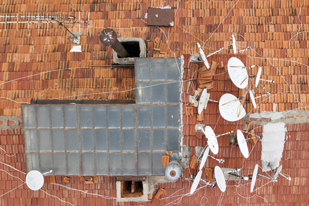
Different photographic angles can then provide a more complete, multi-dimensional view of the building and its surroundings. Oblique photography can offer a side or façade view of buildings, the condition of the windows, the number of floors and the construction type. Adding top-down aerial photography can create a plan view to help identify any issues with flat roofs, solar panels or other roof fixtures.
Drones have also become a common tool for understanding property risks. A combination of drone footage and LIDAR can help calculate a building’s exact height and measurements, which is valuable for old buildings where no plans exist. For example, in some cases regarding historically significant buildings, the technology is being used to create calculations as a precautionary measure in case of fire.
Flood events are also prime use cases for drones, which can capture images that provide immediate understanding of the areas impacted when a flood barrier or river is breached. Once the area is surveyed, geospatial data visualization tools such as LexisNexis Map View allow a polygon to be drawn around that area so that insurance providers can immediately identify policyholders affected and get loss adjusters to the scene. This information can also better direct risk mitigation efforts to prevent future flood losses.
Environmental Risks
In addition to showing the type of construction and size of a building, imagery can also indicate where a property sits in relation to other buildings. This is helpful when it comes to understanding how fire could spread or identifying other localized environmental risks.
With the decreased cost of LIDAR technology, the flood, fire and subsidence risk models created through captured images have become even more detailed. Three-dimensional maps of the terrain can be created showing buildings, trees and water levels for vast areas of land, which can be particularly valuable in flood modeling. By combining this data with soil type, average rainfall data and river gauge monitoring, you can predict where water will go in a flood with reasonable accuracy and develop disaster response plans accordingly.
The evolution of geospatial data visualization tools means that risks can be assessed down to the building outline level. As the number of severe weather events increases due to climate change, this information is becoming increasingly valuable.
Geospatial data visualization tools offer an opportunity to speed up the risk assessment process for perils and can provide valuable insights around specific conditions that increase risk to a property. Data and imagery can also help solve some of the under-insurance challenges in commercial property. For now, however, an actual surveyor is still required to visit sites to collect information concerning security, construction type, internal contents and other factors. In time, this data will become more digitized and connected devices such as security systems and water sensors will allow information to be fed to risk managers and insurance providers in real-time to minimize damage as early as possible.